BARTON
UPON HUMBER
A Town With A Past --- And A Future™ |
||
Home History Section
Georgian Walk Victorian Walk

There are areas at the start of this walk which may be unsuitable for wheelchairs as it includes a section along the river bank and down through the country park. There will be a note to avoid the worst areas though there will still be areas which may be over grass. Also in wet weather or after periods of rain there may be sections in the early sections where it can get quite muddy so appropriate foot wear may be needed.( If only taking the virtual walk please feel free to wear your slippers. )
Click on photo for larger version
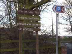 |
We start this
walk in the car park for the Humber Bridge viewing area. For
directions to Waterside Road visit the web page Barton
Street Index . The
car park is signed on your left just before you reach the end
of the road. Once in the car park
notice the beacon pole which was erected as part of the beacon
project for the millennium celebrations. Now walk up the slope
onto the bank and turn right to get to the end of Waterside Road.
|
 |
|
|
On your right is the old boathouse. This was originally used as a Coastguard station and was opened by the Duke of Edinburgh in 1880, but closed in the 1920s. During the second world war it was used by an army unit. It is now the visitors and information centre of the Barton Clay Pits Country Park Project and the start of the Viking Way, which is a long distance walk that ends at Oakham. It is open from Easter to September and attracts some 25,000 visitors each year, many from overseas. |
|
 |
If you now turn
and look across the river you get a good view across to East
Yorkshire. Barton ferry, mentioned in the Doomsday Book, sailed
between Barton and Hessle until the 1850s. It was one of the
several ferries crossing the Humber. At very low tide you can
just make out the wooden supports of the old jetty which was
later used by the Coastguard station. A freight service operated
between Barton Haven and the Horsewash in Hull until the 1950s.
Hessle with its church and shipbuilding yard, can be seen from
here. The river is tidal at Barton and at low tide, in autumn
and winter particularly, the mud supplies rich feeding for wading
birds. |
|


|
Walk
back along the bank towards the Humber Bridge. |
||
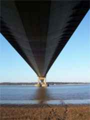
| This was started in 1972 and was officially opened by the Queen on the 17th July 1981. It was the worlds longest suspension bridge though now has been moved into second place by a bridge in Japan. The Humber Bridge has a total length of 2,220 mtrs or 2,430 yards. The bridge is operated by The Humber Bridge Board, formed by an Act of Parliament in 1959. |
|
|
| There are walkways and a cycle path on each side of the bridge and a little later in this walk we will be close to the point where you can reach this pathway should you want to extend your walk onto or over the bridge. Whilst there is a toll for road vehicles it is free for pedestrians and cyclist. | ||

|
|
Continue along the bank and under the Humber bridge roadway and notice on your left the anchorage block for the cables. Each of the two main supporting cables is made up of hundreds of thin cables each of which was individually taken across the river. At each side of the river is an anchorage block into which each of these individual cables is anchored in concrete. | |
| Also as you pass under the bridge look out across the river at the view between the towers. | ||

| If you continue a little further you will come to the Blyths Tileyard. This is one of the two tile yards still working in Barton today. In 1900 there were 15 working yards in the parish producing both bricks and tiles. The products were sent from wharves on the Humber Bank all over eastern England and many houses in Londons suburbs are roofed with Barton tiles. Many of the workers in the industry lived in cottages built in the yards of which one pair remains here. The industry has steadily declined since the first world war. The many remaining ponds, marking the pits from which the clay was extracted, are evidence of its former importance in the economy of the town. |
|
|
|
Now walk back
under the bridge and just after the gateway turn right down the
steps into the Clay Pits Country Park.
(It is outside the scope of this walk but if you had continued along the bank past the tile works for about a mile you would have come to another of the Clay Pits Country Park sites which forms a circular route and contains hides for watching the birds on the water and also takes in the visitor centre.) |
||
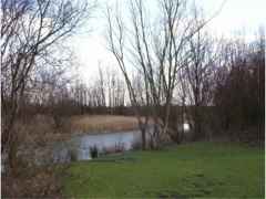 |
Walk along the grassy path with the approach road to the bridge on your right until you reach the pathway and then turn right. On your left you will see a pond which was originally formed when clay was extracted for the brick and tile works. If you had walked just past the tile yard you would have seen a new one of these pits being dug out as clay is extracted for the working tile yard. Nature has re-colonised the pond, particularly with reed-mace and reeds. A variety of birds can be seen including most commonly mallards, moorhens and coots. |
|
| This area was once used for the now abandoned Waterside Sports. This annual event was held in August with separate races for boys, girls, men and women. The last Waterside Sports were held here in 1947. | ||


|
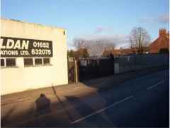
Continue along Dam Road to the end and turn right. If you look to the left across the road you will see the railway station. This was opened by the London North Eastern Railway in 1855 though trains had actually reached Barton in 1849. It was formerly a very busy place with a lot of freight and passenger traffic. In 1901 fourteen trains left Barton each weekday and 4 on Sundays. The station buildings were all demolished in 1973. There were plans at one time to continue the railway line to Scunthorpe via Wintringham but this was never started. There is still a service to Grimsby and Cleethorpes and these link with the bus service to Hull and Scunthorpe. |
|
|
 |
Continue along Waterside Road / Fleetgate to the White Swan Inn which was one of Bartons main hotels. It is a three storied building with a steeply hipped pantile roof. The Venetian windows looking onto Fleetgate indicate that it was built in the 18th century. It formerly had a stabling and a paddock at the rear. | |
|
Now turn around and walk back along Waterside Road. In the 19th and early 20th century the Waterside was a self-sufficient, tightly-knit community with its own shops, schools, church and Methodist Chapel, inns and industries. Many of its inhabitants rarely ventured into central Barton but instead used the railway and ferry to visit Hull. Its industries included brick and tile making , a rope works, a chemical works, malt kilns, shipbuilding and repairs, a gas works and a whiting manufacture. The area has become somewhat run-down though there are hopes that a revival of its fortunes is underway. |
||
| Notice on your right the road Maltkiln Lane which was named after the malt drying kilns which were in that area. Some years ago they changed the name of the road to Chemical Lane in response to the chemical works which was at the end of the road. Since its demise a few years ago they have now reverted back to its original name. The name Maltkiln was taken from several malt drying kilns in that area. | ||
|
|
As stated earlier the waterside area was a busy self sufficient part of the town. There was very much a feel of them and us between this end of the town and the market place with the two areas not mixing to a great degree. As with all dockland areas there was a ready supply of public houses within the waterside area and most of these are no longer open for selling alcohol. One of these is the Royal Vaults Public House. This closed in the mid to late 1900s and has not been turned into flats. When this public house closed it was at the time when new public houses could only be granted a licence which had become available from one closing. The licence from the Royal Vaults was kept and used for the newest of Bartons pubs the Carnival Inn which is on Tofts Road. | |


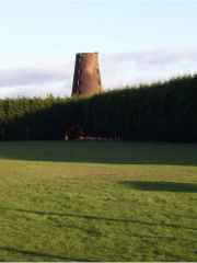
| Continue down Waterside Road until the houses Nos. 23 and 25 on your left. These were originally one house which belonged to the owner of the windmill situated to the Northwest. It was built in the early 19th century. The Turnpike road from Barton-Waterside to Lincoln which started from here was opened in 1765. |
 |
|
|
Notice over the haven the building which was part of the rope works. This was used as the loading point for the barges along with some packing. As can be seen the haven was navigable up to this point. In fact it was navigable far further into Barton than this centuries ago. |
 |
|
|
|
Many buildings along the Waterside have recently been demolished. Among them was St. Chads Church whose foundation stone was laid on 11th June 1902 by the Bishop of Lincoln. It cost £1,850 to build, was closed for worship in the 1970s and was finally demolished in 1993. St. Chads Church of England School was opened on 12th December 1904 after a public inquiry. At that time there was much opposition to Church Schools and Church teaching. The school was closed in 1960 and was demolished in 1993. | |
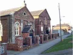
| A little further down the road is the old Wesleyan Chapel. This was built in 1862 as a mission chapel and was designed by the Hull architect W. Alfred Gelder. The original Mission Chapel on the south side of the site was converted into a Sunday School when the new chapel was opened. After it ceased to be used as a chapel it was used as a headquarters of the Boys Brigade until it was closed. Since then it has had various uses mainly as storage for organizations and businesses. |
 |
|
|
|
There was once boat landings along the banks of Barton Haven all the way down Waterside. It has to be remembered that the embankment you now see has been a fairly recent addition o the landscape and was designed to stop the flooding of the property when there were exceptionally high tides. Barton clearly had a great port in the medieval period and although it declined somewhat in the 16th and 17th centuries a revival of its fortunes took place in the 18th and 19th centuries when goods, including bricks, tiles, whiting, chalk, gravel, sugar beet, fertiliser from the Farmers Company Works on Chemical lane, barley, coal, rope and hemp, were transferred to and from sloops, keels, coasters and London sprite-sail barges. These traded with inland, coastal and continental ports via the River Humber. Many of the sailors who manned these boats lived in the houses and streets which lined the Waterside. Most of this river trading finally ceased with the outbreak of the second world war but a market boat continued to journey from Barton Haven to Hull until the late 1950s. |
|
| You come to the new bridge which has been built over the haven. This bridge replaces an old bridge which was called Ropery bridge and was taken down many years ago. The old bridge was much nearer the town than the new bridge but this new location gives a fine view of the boats in the boat works and also easier access from the river bank on the west of the haven to the east side. |
 |
|


  |
If you now cross the bridge and then turn to the right and follow the line of the haven you will come to a long building which now houses the Ropewalk exhibition centre but was originally part of the rope works. John Hall ( 1775-1863 ) developed the ropery which became known as John Hall and Co. By 1900 about half of the ropes produced here were sold to the Wilson Shipping Line, the largest private shipowners in the world at that time, and the remainder went to trawler companies in Hull, Grimsby and Lowestoft. The firm expanded greatly during the early years of the present century but gradually trade declined and the rope works closed in 1989. The buildings which now remains of the old works are the warehouse with its mansard roof and loading crane and the ropewalk. which is reputed to have the longest pantile roof in the country, some one third of a mile long . | |
| Now return to the bridge. On your right you may see the entrance to another country park which has been developed on the site of the old chemical works. Again this is outside the scope of this walk but hopefully will form part of a future walk. Now back over the bridge and turn right. | ||
| Continue further down Waterside Road and opposite the boat yard is Waterside Cottage. Which is probably an 18th century building and was once attached to a malt kiln which occupied the site which is now 101 Waterside Road. After being used as a malt kiln the building was used as a wire works. |
 |
|
|
|
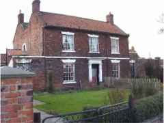
A little further down Waterside Road is Waterside House which was originally known as Waterside Inn and dates from 1715. During its heyday from about 1723 to 1835, the inn must have been a most important and prestigious establishment with three mail coaches using the Inn. The Royal mail coach to London ran daily from here. In 1821, when a steam ferry commenced running between Hull and Barton, the Inn had stabling for 100 horses. The mail coaches stopped running when the New Holland Ferry and rail connection opened in 1849. The Inn became a ferry office and was later converted to a public house much frequented by boatmen using the waterside. Since 1960 the building has been a private house. |
|
| The large house near to Humber Terrace called Beech House which was once owned by North Midlands Railway ( ferry service ) was later taken over by the Coastguard service and used as accommodation by the officer in charge of the station. | ||
 |
Continuing further on you will see an L shaped group of eight cottages. These were the Coastguard houses built by Alexander Stamp in 1862. Alexander Stamp built the houses for William Wilkinson, surgeon, of Cob Hall. There were houses for the families of the seven boatmen and one leading boatmen, with a communal wash-house serving the dwellings. These coastguards had previously lived in houses on Waterside Road. The Admiralty originally leased the houses from Wilkinson for 21 years, but bought the properties on his death in 1883. | |
| The coastguard launched their boat from the old jetty which had been built in 1825 for the new steam ferry ( see the beginning of the walk). For over a century Bartons coastguard station was the headquarters of the service along the Humber. The jetty was demolished in 1929 when the station was closed. More information can be found in the section about the Coastguard Station on this site. | ||
|
You can now walk down the north side of these houses into the car park and you have completed the circular walk and have seen some of the history of Barton as a busy river port. Whilst I hope you have found this virtual tour interesting it can never replace seeing the places "live". We hope that you may find the time to visit the town and experience its history. Please visit the EVENTS page for information about the dates and times of the active life of the town. |
||

